
Collections III: Maps
A series

In the summer of 2022, my cousin Andrew and I visited an art gallery in Beirut. Calling it an “art gallery” is generous of me; it was more like a chaotic art collector’s basement. Tucked away in a side-street of Hamra, the place is owned by a jovial and enthusiastic septuagenarian man who immediately welcomed us in and insisted on giving us a tour. He showed us the different rooms, explained how they are organized and how he chooses which art pieces to display, and gave us a placard with an image of old Beirut on it. Then he left us on our own to explore. It was mid-July, the rooms were warm and ventilated only by a couple of tired fans, and a slightly creepy version of “Il est né le Divin Enfant,” sung by a choir of children in a minor chord, was playing repeatedly on the speaker. There was a migrant worker who assisted the owner with the store; he made us Turkish coffee. At one point, the owner said: “I believe it’s very important that everyone has to collect something. Do you collect anything?”
I collect many things. “Collections” is a series where I meditate on the act, meaning, and substance of collecting.
Do YOU collect anything? I’m interested in talking to other people about what they collect, why, and how. Please reach out if you’re willing to be interviewed by me.
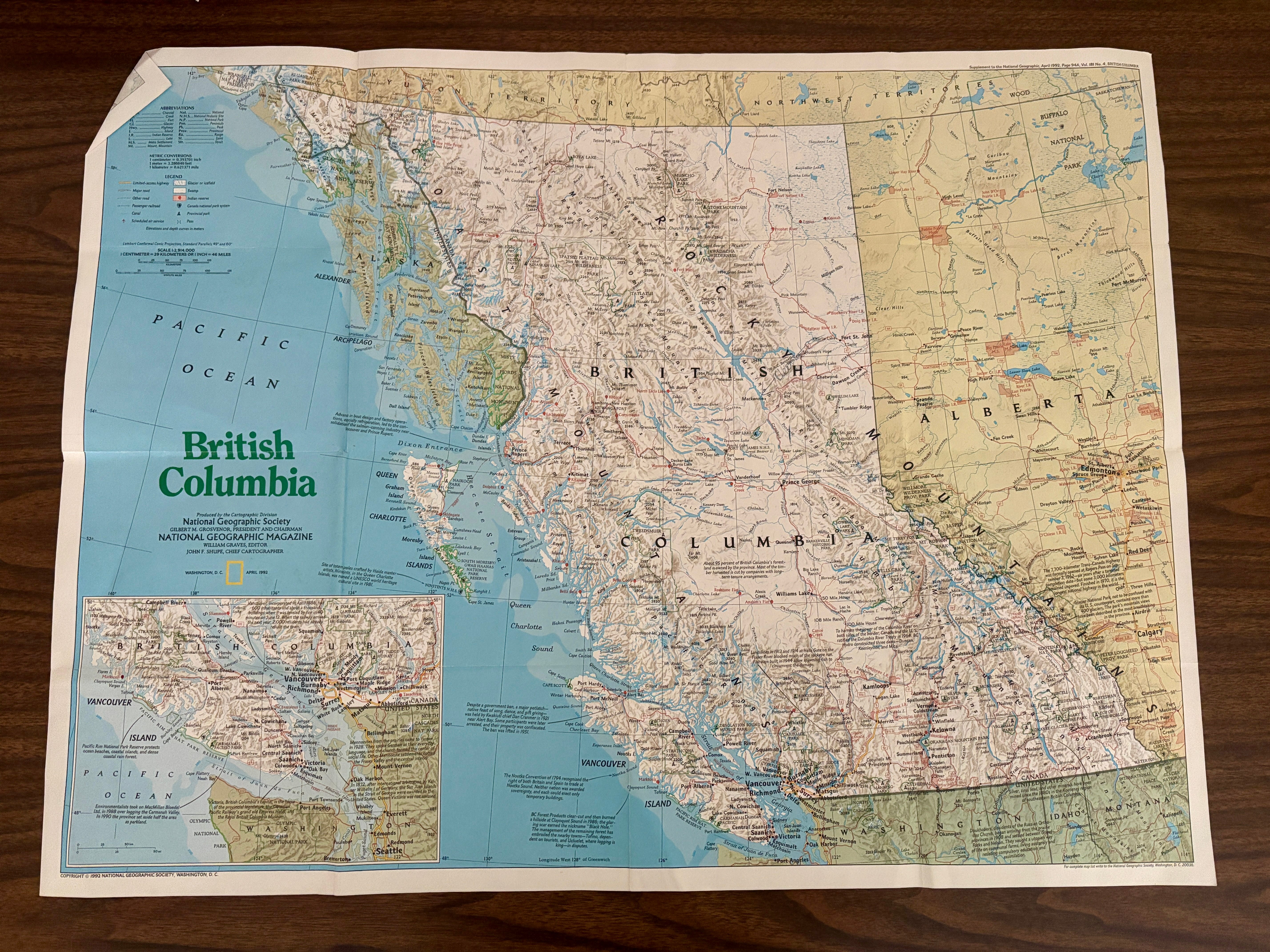
When I was a child, I often spent time rummaging through my father’s storage closet. One day, I found his old maps of British Columbia and the United States. I took them out and added them to my collection of assorted adventure books and diaries, because I fancied myself an explorer, and I knew that maps would help me on whatever my imagined quest was for the day.
“Maps are powerful images. They affect us consciously and unconsciously. They tap into our sense of adventure. When we pick up a map we become explorers investigating lands that represent new horizons to us. Many of us have reverence and awe for maps, or are at least attracted to them.” – Seeing Through Maps, pg. 96
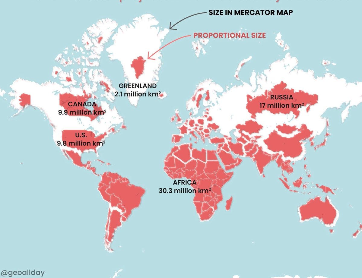
Over the years, I began appreciating maps for other reasons. Notably, I remember a middle school social studies class where my teacher displayed an old map of the world, which I found out later was called the “Mercator” map, and asked us to consider the depicted size of continents like Asia and Africa versus Europe and North America. The teacher then compared the size of the continents on the map versus the actual size of each continent, showing that the map-maker subconsciously made it so that North America and Europe far exceeded the size of, say, Africa, when in reality this was not the case. Most people might find this lesson familiar.
“Mental maps tend to exaggerate the northern hemisphere while downplaying areas near, and south of, the equator. Europe, Greenland, and Canada are regularly shown larger than they really are. Greenland is sometimes blown up to about 600 times its actual size. Even people who do not live in Europe or North America tend to exaggerate the prominence of those areas, mimicking the lopsidedness of Mercator-based maps. Given these results, can there be any doubt that the Mercator image of the world remains very influential? As an image, it powerfully shapes the worldview of countless people.” Seeing Through Maps, pg. 34
This was the first time it dawned on me that maps are interpretations of space rather than its objective representation.
Maps & Space
I can’t read maps. If you gave me a map of the Boston tram, for instance, I would stare at it for hours completely lost trying to figure it out. I appreciate maps as images, artworks, cultural representations, and ethnographic data.
As a university student, I spent a summer abroad studying in New York City. I was completely hopeless at reading the city’s complicated, grid-like map, and instead, I found myself relying on landmarks to make my way back home from the university campus every day. I knew that, once I got off the subway, I had to look for the TJ Maxx and walk alongside it in a straight line. Then I would reach some other store or another, and know that I had to take a right, walk for a few blocks, and reach my apartment.
In Beirut, despite my own lack of map-reading skills, I would still get annoyed at Uber drivers when I got into their car and they asked: “Where are we going?” Why doesn’t he just look at the map, I asked myself frustratedly, even though I knew the answer. Maps have never been the way in which people navigate space in Beirut. Instead, landmarks are used to navigate the city and to give directions. According to anthropologist Kristin Monroe, who wrote a book about mobility in Beirut, this is because of the “lack of standardized names for streets, absence of numbered street addresses, and inadequate signage.” Beirut is a city where streets are commonly referred to by a variety of names – and so the destination is usually a landmark, neighborhood, or intersection, rather than a straightforward address or location on a map.


So then, what is a landmark? A landmark is a space, shop, monument that is recognizable and can be used as a reference point. Interestingly, even after some stores, shops, or restaurants close, people still have them mapped out in their heads, and they give a sense of direction. “You remember where BankMed used to be on Hamra Street? That’s where we’re going,” I tell the Uber driver. BankMed’s branch on Hamra Street closed many years ago.
This over-reliance on landmarks can be almost comical at times and infects the way that people “formally” or “officially” describe a space. In “Memories of Ras Beirut,” a documentary by Mahmoud Hojeij, Dr. Munir Shamaa explains the borders of Ras Beirut by saying: “Ras Beirut is bounded by the sea on the North and the West and the Bristol Hotel on the South. It’s also bounded by the Al Sanayeh area on the East.” The fact that a hotel – a building, when it comes down to it – is used as a legitimate marker of space borders is taken completely for granted. But it says something about the way people imagine and navigate space, and the very particular cultural understandings of space that are at play here. And the way people imagine space has to do with the way they exist and live in it, the way they relate to it, and the way space is made and constructed.


Beirut: The Unmappable City
While conducting fieldwork for my Master’s thesis on Beirut’s street cats, I realized that there exist many different maps of Beirut in people’s heads and in real life.
For example, the space of “‘Ayn el Mreisseh” is contested according to the map – or the person – that you refer to. The neighborhood’s administrative boundaries are different from the borders described by the residents. According to the municipal map, ‘Ayn el-Mreisseh is located between the Ras Beirut area to the east, the American University of Beirut to the south, and the seashore promenade, known as Rue de Paris, to the west. But anthropologist Aseel Sawalha found that the neighborhood’s residents rejected these municipal borders. In her interviews with them, she learned that residents instead constructed varying mental maps: some included the entire area of Ras Beirut, others incorporated segments of the downtown area, a third group claimed the American University of Beirut, and a fourth group included only a few of the area’s inner streets. But none of them used the municipality’s official name, Dar el-Mreisseh, nor its administrative borders.
“Listen, I am the one who could tell you the real borders of ‘Ayn el-Mreisseh,” a prominent Sunni politician said to Sawalha assertively, “It is the area that is located between the sea from the north, Bliss Street to the west, Clemenceau Street to the south, and Al-Huson Port to the east. This is the real ‘Ayn el-Mreisseh. Do not listen to anybody who gives you other borders.” But the fishermen of ‘Ayn el-Mreisseh offered Sawalha yet another map of the space:
“For As’ad, a forty year old fisherman who had lived and worked in the area all of his life, “Ayn Mreisseh consisted of the fishing port, the Corniche Street, and the whole Mediterranean Sea. “For us, the water is part of the neighborhood… We face the sea and turn our backs to the land.” Like As’ad, the fishermen, who were among the least powerful, contested their marginalization and declared the fishing port to be the most important marker in the area.”


While working on a cultural heritage project called Ras Beirut Al’an, I read a book by sociologist Samir Khalaf and geographer Per Kongstad called Hamra of Beirut: A Case of Rapid Urbanization and an MA thesis that closely engaged with the book to compare Hamra of today with Hamra of the 1970s. Khalaf and Kongstad’s book contains a series of cartographic elements and analysis from the Hamra area in Beirut, Lebanon, to explore how changes to space affect social relationships. They argued that Hamra is an example of how urbanisation can be defined in different ways: as a physical and demographic phenomena and as a way of life. The authors, in writing the book, made and relied on a total of 47 maps varying from work maps to final versions for printing. During this time, I also read Maria Abunnasr’s “46 Streets: AUB’s Imprint on the Streets of Beirut,” a pamphlet that provides a history of the streets of Ras Beirut and the AUB-related characters they are named after. The breakthrough was when I discovered the Beirut Urban Lab’s book Refugees as City-Makers, which finally took seriously the malleable and flexible boundaries of the city’s spaces and borders. The maps in this book are incredible.
Throughout this process, I was trying to understand if and how Beirut can be mapped, and how its space can be understood. Maps became intriguing to me precisely because in Lebanon, they are mostly irrelevant. The physicality and tangibility of maps in Lebanon is not helpful. What instead pervades is the inhabitants’ imaginaries of space. During a family lunch years ago, I asked my parents, sister, uncle and aunt, and cousin: What exactly is the space that we call “Ras Beirut”? Which area does this cover? What are its borders? A full-on family discussion proceeded, because no one quite knew. Everyone pulled out maps on their phone to discuss, and we discovered that “Hamra” is not just a street, it is also a “sector.” That is why there is a space called “Hamra” as well as a street.
Months later, a friend was telling me about the project she was working on where a research team will be going around the city and doing surveys with local store-owners/enterprises. I asked her about the location of the study, and she said “around Hamra.” I asked “Does that include Ayn el-Mreisseh?” She said yes. I thought: But Hamra and Ayn el-Mreisseh are two different sectors! This city and its inhabitants confounded me.
Mapping Beirut
So let’s get down to the facts, or what we know of this city that can’t be mapped. I learned by reading the MA thesis by students foreign to my native city that
Beirut is divided into electoral districts and quarters (or sub-districts), locally called mahallat and manatiq respectively. Officially, the city is composed of twelve mahallat and sixty manatiq, each with a name and number. The quarters are also called sectors or “secteur” because they were created during the French mandate (1920-1946). However, the definitions and divisions are somewhat arbitrary and ambiguous and names are used interchangeably across divisions.
Attesting to the utterly confounding yet charming nature of this city, names can occur several times with different meanings – which is how “Ras Beirut” can refer to the mahallat Ras Beirut or the manatiq Ras Beirut, or how Hamra can refer to both the street or the mantaqa. To confuse things further, the mantaqa Ras Beirut is not within mahallat Ras Beirut, but in mahallat Ayn el-Mreisseh. It is rarely clear which of the two definitions of Ras Beirut people are referring to, which “may be because Ras Beirut (and Hamra) is historically recognised by its social, cultural and economic diversity and therefore has fostered different perceptions and definitions of the areas size and limits.”
Another potential element of confusion is the street naming system. The streets in Beirut are also numbered starting from 1 within each quarter. The actual name of the street is not on the sign, which is normal practice in Beirut, although all streets do have names. To make matters even more absurd, if you buy a map for navigation in the city, it will usually have the street names but not the numbers.


Collecting Maps
One of my favorite things about maps is that they allow us to read about places that exist in the world and the funny names they have. We can imagine that this place exists for some people, that they walk and traverse it everyday. This is a space that holds meaning for them, that is a part of their home. Some places have funny or interesting names, and I always marvel at the fact that for the people who live there, it’s just another name that rolls off their tongue without much thought.

For instance, the name “Ayn el Mreisseh” is so commonly used and such an intrinsic part of Beirut’s neighborhood that its residents don’t think twice about it, but the name itself is meaningful. Sawalha writes that the name stems from a particular myth:
“A long time ago, a boat that carried nuns sank in the sea. A lucky nun survived and managed to swim safely to the shore. She stayed next to the water spring in the neighborhood and lit candles to thank God for saving her life. The curious children of the fishermen who lived around the spring came to see the nun. She taught them reading and writing. To express their appreciation, the fishermen built the nun a room next to the spring, and gave her the title of Rayseh [female chief of the fishermen]. Since then, the neighborhood came to be called ‘Ayn el-Mreisseh, or the ‘spring of the fisherwoman chief.’”
I always cite the example of ‘Ayn el-Mreisseh because I think it is such a magical story. But there are other examples of the ways in which the names of spaces and places, most of which have become second-nature and boring to us native inhabitants, derive from the histories of the people who built their lives in – and with – that space. In Hojeij’s documentary, Kamal Rbeiz, former Mukhtar (elected neighborhood headman) explains the history of naming within Ras Beirut:
“The whole area of Ras Beirut was named Zikaki Tantass 1. Lebanon was invaded by the Ottomans and then the British and French. They reached a compromise. The name is Turkish, Zikaki Tantass 1 and 2. When the British arrived, they named “Hamra Street” as “London Street”. When the French came, they named “Jeanne D’arc Street” as “Champagne Street”. Then in the 1960s, the municipality of Beirut started naming the streets, giving the names of the notable and traditional families in the history of Ras Beirut. “Hamra Street” was named after the “Hamraa” tribe (Kabilet al hamra’). These tribesmen came from the Bekaa and settled near the “Zawiya” mosque.”
As Maria Abunnasr writes, Beirut’s street names are tangible evidence of how people “make place.” In the same vein, I collect maps because living in Beirut taught me that they are fabrications and fabulations rather than “objective representations of reality.” The book Seeing Through Maps says that maps are descriptions, not representations. Every map is a “purposeful selection from everything that is known, bent to the mapmaker’s ends;” every map is a “view of the globe” from a particular perspective. Different maps are like telling a story, but from different points of view (pg. 8).


I like to think of maps as artworks that represent often-collective imaginaries of space. Because, like photographs, maps are a graphic way of transmitting information, and so they do tell stories of their own. I like to wonder about the stories that maps tell and that they don’t tell; the questions that maps give voice to or ask of us.
Do YOU collect anything? I’m interested in talking to other people about what they collect, why, and how. Please reach out if you’re willing to be interviewed by me.